ST MICHAEL’S WAY- THE OTHER, SHORTER PILGRIMS’ ROUTE ACROSS CORNWALL.
An article by Robert Shaw, 2010
One of these “English” routes comes out of Cornwall and the reality is that, as the crossroads of the “Celtic fringes” of Europe, Cornwall was a departure point for countless pilgrims heading to Santiago. Cornwall has only recognised this in recent years. The first “official” pilgrimage route was the Saints’ Way between Padstow and Fowey, for which the few available guides scarcely mention the Camino to Santiago.
More recently. however, a second route has been opened, with Euro-money, and which positively incorporates the scallop shell in its signage. This is called St Michael’s Way and runs 12½ miles between St Ives Bay, on the north coast and St Michael’s Mount, on the south. We walked this route in Spring 2010, between completing the Saints’ Way after Easter and setting out for Northern Spain for our Camino.
It was a fine, sunny morning in Lelant, where the Way officially starts, and we had left our car at the end of our walk, in the car park at Marazion, and had taken the local bus which runs across the narrowest bit of Cornwall, to our starting point.
St Uny landed at this thriving port in 600AD and Celtic Christianity survived here until the Roman church eventually gained power in 930AD. Before the estuary silted up in the 16th Century it was possible to sail beyond Lelant to Hayle and even to St Erth. However, St Ives then became the main port.
We decided however to omit the first mile or so of walking in what appeared to be the wrong direction and between the railway line and the golf course, and stayed on the bus until Carbis Bay. Here St Michael’s Way has turned inland, has crossed through the village and begun to lead quite steeply uphill. From a distance we saw a tall pointed obelisk on a hilltop. The Way passes close by so we investigated it. The three-sided granite monument was erected - to his own glory and with the intention of it becoming his mausoleum - in 1782 by John Knill.
Knill was the local Collector of Customs in St Ives and it can only assumed that the monument result from excessive “collections” and excessive hubris! There are great views of the coast (including Godrevy lighthouse which inspired Virginia Woolf) from “Knill’s Steeple”, but we pressed on.
The Way is partly on minor roads, partly paths, across fields and even crosses a campsite. It was not long before we reached Trencrom Hill. One of the glories of walking in Cornwall in the Spring is the blackthorn blossom, and here, approaching Trencrom, it was in profusion, combined with field boundary walls built with huge, neatly interlocking granite boulders.
The Way skirts around the foot of Trencrom Hill, though there can be few walkers who do not go up to the top, 212 metres above sea level, for one of the finest views in Cornwall. This is another outcrop of massive, weathered, rounded granite. There are said to be sixteen hut circles here and Neolithic axeheads have been found which date to 3,500BC.
Halfway down Trencrom we met a gentleman on his own, climbing up, so we stopping to chat, we explained that we were preparing for our Camino and he revealed himself to be a local Vicar (we eventually sent him a postcard from Santiago) he wished us Buen Camino and warned us about a detour within the next mile, where a local farmer had (allegedly) diverted the right of way.
At the bottom of the hill we came to Ninnes Bridge, where the Way runs alongside a stream through the front garden of a converted Wesleyan chapel. Climbing the other side of the valley we reached Trembethow and, as had been foretold, we were totally confused by the absence of signage and much recent wire. We incurred a significant detour – together with several un-Christian thoughts!
We re-joined the Way as it formed a beaten line across a ploughed field, then down steeply and up steeply several times, over several kilometres, until we reached Ludgvan. St Ludgvan’s church was a meeting point for pilgrims making the final leg of the journey to St Michael’s Mount, which ran through thick forest and then across marshland.
Next door to the church is the White Hart Inn, the first pub we had come upon and where we drank lunch and readied ourselves for the final straight (almost literally). The Way runs downhill from Ludgvan along field edges, where arrangement of granite slabs act as cattle-grids. The heavy forest has long disappeared and we crossed the A30, and then the A394, as the Way finally reaches sea level.
The ancient forest may have disappeared, but the marshy land remains. Marazion Marsh is now managed by the RSPB as an important habitat. The Way crosses these marshes on raised decking. It also crosses the main Penzance to Paddington railway line, with surprisingly little security!
Finally we emerged onto the seafront of Marazion and the car park. Ahead was St Michael’s Mount, accessible by foot over the causeway at low tide, but now, in mid-afternoon, separated from the mainland by high tide. Knowing it well already, we decided to forego the boat-trip to the Mount and back, and drove home instead.
Our next cross-country walk would be following the scallop shells and yellow arrows westwards out of Leon.
Reproduced with permission from Robert Shaw.
To download full article with images , and also anothet by Shaw about the Saints Way
please click on link buttons below.
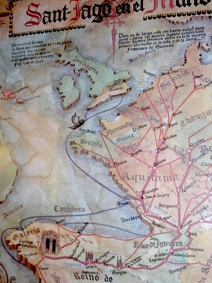
The historic-looking map in the lobby of the Virxe da Cerce hotel in Santiago, shows the converging pilgrimage routes from all corners of Europe, including two separate routes leaving from England.
Curiously, the CSJ Pilgrim’s Record map shows no routes starting from England at all! *
(cont'd below)
* see note at foot of page.
< Click on image to expand
Photo courtesy Robert Shaw
 St Michael's Way PDF
Saints Way PDF
St Michael's Way PDF
Saints Way PDF

* notes : Since this article was written Janet McEwan has been in conversation with CSJ (Confraternity of St James) and it is hoped that St MW will shortly be more visible on their website, not least as there is now a new 'Compostella Package deal in place which will enable walkers who complete both the English Way and The St MIchael's Way, or one of several other shorter pilgrim routes in the UK, to receive a Compostella.
More info on that here on this website soon.